
Okay, so I’m not maps and genealogy all the time. Some will know “Stay a While and Listen” comes from my go to game, Diablo. The line has been said in every version from the first release. I need something to set my mind on while difficult puzzles seek more answers.
Today of course I’m talking about maps. Big is the term “map date” among historical and genealogy researchers. More importantly most think of map date in terms of the year. Many tools we have available to view historical maps even work as seen below by selecting the year of the map you want to look at.
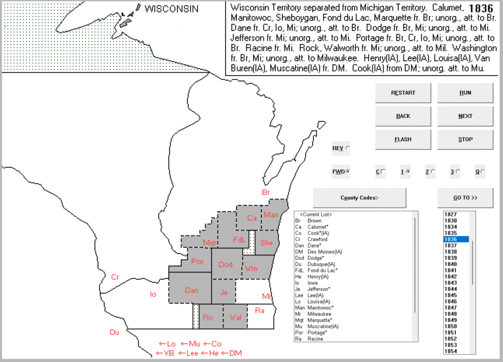
What you see is common when searching for historical maps. With AniMap 3.0.2 it was leading edge technology at the time. John Long was still working on the Atlas of Historical County Boundaries. The internet was not real big and people who knew of the project we limited. Back when AniMap was created, Bitmap files were used for the maps you see. This was a massive accomplishment giving historians and genealogists historical map information at their fingertips.
Details on changes, although limited, included all changes in that year. However, the potential complexity of where you search for records still exists in these types of historical maps.
Consider we are searching in 1836. During this time from 6 Sep 1834 until 3 July 1836, Brown County, Wisconsin looks like the map below.
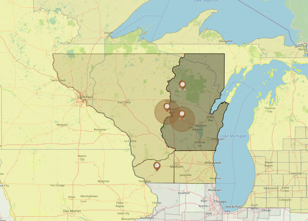
Searching in 1836, from 1 Jan 1836 until 3 Jul 1836, Brown County looks like the map above. Notice the top part of the thumb, it is located in a Non-County Area and is undefined. Government would have been at the Michigan Territory level since the date is before the Wisconsin Territory is created.
This discovery points out how using years for map dates during these times can give misleading direction. In 1836 the Wisconsin Territory is formed. The specific date Wisconsin becomes a territory the map changes. The map above also points you to the Michigan Territory for your research. A location you may or many not know based on the AniMap 3.0.2 and other mapping programs.
On 3 Jul 1836, Wisconsin is not an official territory as Michigan is granted statehood. The map below indicates what Brown County, Wisconsin looked like on this date.
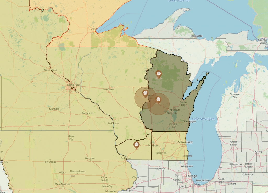
As you can see in the two AniMap 4.0 maps above, Brown County, Wisconsin still does not look like the 1836 date in the first image from AniMap 3.0.2. This does not make AniMap 3.0.2 or others using years to display map dates wrong. It makes them not as concise as what can be found in AniMap 4.0.
Missing in the by year map date are the specific date changes those took effect on. Overall this is not important in some cases. However, when deciding where an ancestor was born, what county and event happened in; dates are critical as depending upon the date what you are looking for may not be in the county you are looking at.
The year date maps include several counties that do not exist until 7 Dec 1836. If your ancestor or historical event happened before 7 Dec 1836 and did happen in the year 1836; those events would have been in Milwaukee, Iowa, Brown or Crawford counties of Wisconsin Territory or even possibly in the Michigan Territory.
Below is the map of the Wisconsin Territory on 7 Dec 1836.
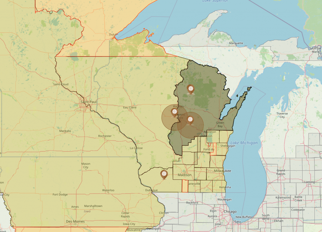
As you can see this map closely resembles the map found in AniMap 3.0.2. Clearly the map found there is based on the last change of the year with no ability to know there are three different maps in 1836.
In genealogy and history map dates are vital in narrowing your search. Having a more accurate picture of what an area looks like on the specific date of the event can make a major difference in what county your records may exist.
AniMap 4.0 is designed to give you a map based on the date range of the event you are researching. Map dates are specific to those dates. With printed maps we find many variables, however accurate the map you hold is, that are not shown. Counties were changing many times in a year and map makers did not have time to update every change event with the maps they produced.
Whether we want to think about genealogy being a love of inches and dates that vary by as little as one day; that is what genealogy is. Knowing and understanding these dates and changes can save you hours of researching in all the wrong places. Having to vet out these changes from historical works created by others who are also missing key dates and details.
Where you discover records truly are the sum of the parts. Historical works, maps, county boundary changes, jurisdictional changes; each vital to finally locating the records and stories to build your family history.