I’ve come to realize based on recent information what I know after eight years of research into the history of Deerbrook, Langlade County, Wisconsin boils down to nothing. I am sure many think they know Deerbrook as I once thought the same. Reality is extreme complexity.
We know Deerbrook today, however, we don’t know the origin of Deerbrook. Even the works of Robert M. Dessureau and Martha Lucas never touched on how Deerbrook came to be.
From Dessureau in The History of Langlade County, Wisconsin: from Government Survey to Present Time he writes on page 219:
Deerbrook, situated on the main line of the Chicago & North Western railway, was named by Edward Dawson, timber cruiser and prospector, who, while camping near the Eau Claire river watched the deer “drink his fill” each morning just as the sun peeped over the hills proclaiming a new day. Thus he called i “Deerbrook,” by which it has since been known.
We need to ask the question, but where is Deerbrook? The Eau Clair River is not small and Deerbrook could be situated anywhere near the current location is. Still Dessureau leaves readers to assume Deerbrook today is where it was when it was founded.
Glimpses of the Deerbrook Community Then and Now was written by Martha Lucas in May of 1951. Early she includes a plat of The Village of Neva. She starts writing about the land grant to the State of Wisconsin in December 1863. I have not researched this completely to know how accurate the date is. However she does describe the land area granted.
Lucas then goes on “in December 1882, the State of Wisconsin granted to Charles M. Upham” ith the description being provided. From this Lucas states “In the same year the State of Wisconsin granted to James T. Reeve”, again describing the grant.
Two things to point out here. First she is highly likely correct with the federal government grant to the State of Wisconsin. However, the “grant” she refers to with both Upham and Reeve would be patents. A land patent is what the first sale of state or federal land to a citizen called. Wisconsin is a federal land state as compared to some eastern states that are state land states. The colonial areas are primarily the only state land states.
During the land rush years this was a case of the federal government giving land to attract settlers. Wisconsin was not one of the territories settled by land give aways.
Having obtained a map with all land patents in the State of Wisconsin, I can point to discrepancies in the dates Lucas is using. More on this to come.
Lucas writes “In 1895 the Northern Land Company, a Wisconsin Corporation, obtained the wooded area of the Village of Reeve and carried on logging for one winter. The company sold the land to Charles M. Upham who had sold it to the company the previous year.” Based on Upham and his career I am sure he only sold the timber rights and not the land as Lucas describes.
Lucas writes “The Village of Neva, though platted later than the Village of Reeve, became the industrial center.” I have difficulty following this writing. As I have stated many times, Deerbrook has a railroad, The Milwaukee, Lake Shore & Western completed rail to both Kempster and Deerbrook in 1881. Both having depots for both passenger and freight. Lucas seems to skirt right around this fact and Dessureau thought it best not to include it.
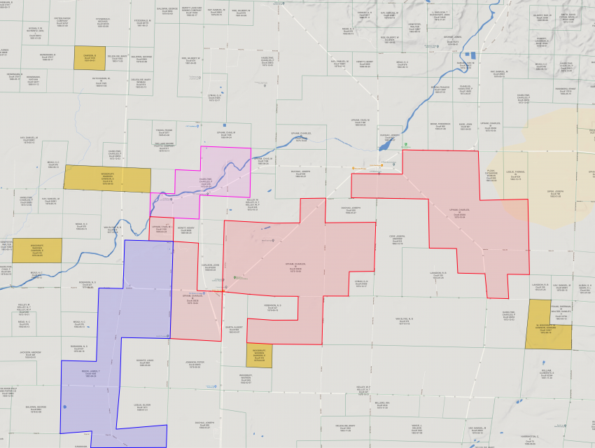
So now let me review what was discovered in the map of land patents. The map and information is courteous of Bay Maps, LLC.
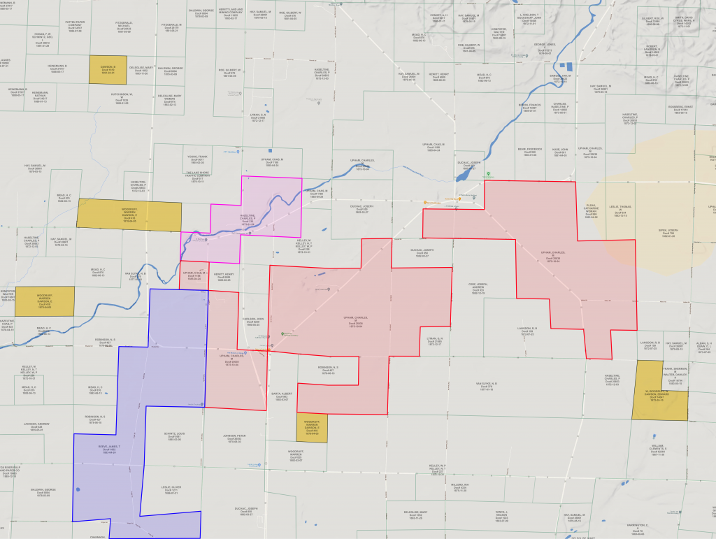
I added the colors to create a more clear view of those names in the histories mentioned.
- Red – Charles Upham
- Blue – James Reeve
- Pink – Charles P. Hazeltine (not in previous histories)
- Yellow – Warren Woodruff (not in previous histories) and Edward Dawson
Charles P Hazeltine, Doc #236, dated 24 Jan 1873 contains the land I’ve always known as Deerbrook’s origin. It is right at the corner of HIghway C and Highway E. Understanding the flow of government, the date of the patent is the date it was created and not reflective of the date of the purchase. Back then people went and picked out their land, went back to the local office to pay for it. In return they were given a receipt and had to wait until the patent was created and sent to them. As much as one year could exist between the payment date and the patent date. Regardless, there is two years between Hazeltine and Upham’s first purchase.
Charles Upham purchases three areas, all of them on 4 October 1875. One purchase includes land around Neva Corners and what will become part of the Village of Reeve. It is not until 24 April 1885 where Charles Upham purchases the land north of Reeve. Two years before he plats the Village of Neva in 1887.
James Reeve purchases a sizable property (goes off the map above), ending on the south property line of Charles Upham. Clearly there was a reason Reeve did not purchase the land bought by Upham two years later.
Now I have an understanding of the land ownership. To learn how the land moves from here will take local land record research.
Additional information I have available is the plat of both villages, Reeve and Neva.
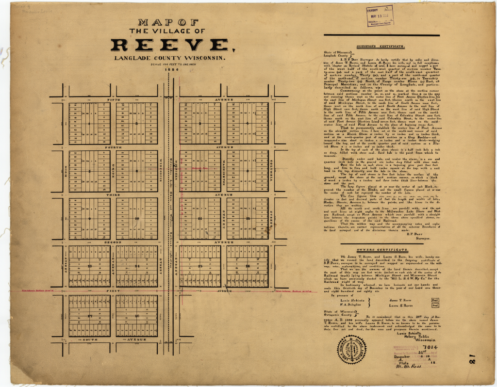
Pictured above is the original plat of the Village of Reeve. The sizable area would indicate the area was growing and Reeve platted this to capitalize on the growing area. To date I’ve not been able to find a homestead in this area for James T Reeve, leaving me currently thinking he was a lumber man only wanting to harvest the timber. That being completed, it would make sense to sell it as a village area whereby he could make more on it than selling it as farmland.
We also see in the plat the area East of Highway E. This area would have belonged to Upham when the village is platted and I can see Upham selling it to Reeve. However, I’m not sure Upham knew Reeve was going to plat the Village of Reeve at the time of the sale.
Enter Upham platting the Village of Neva.
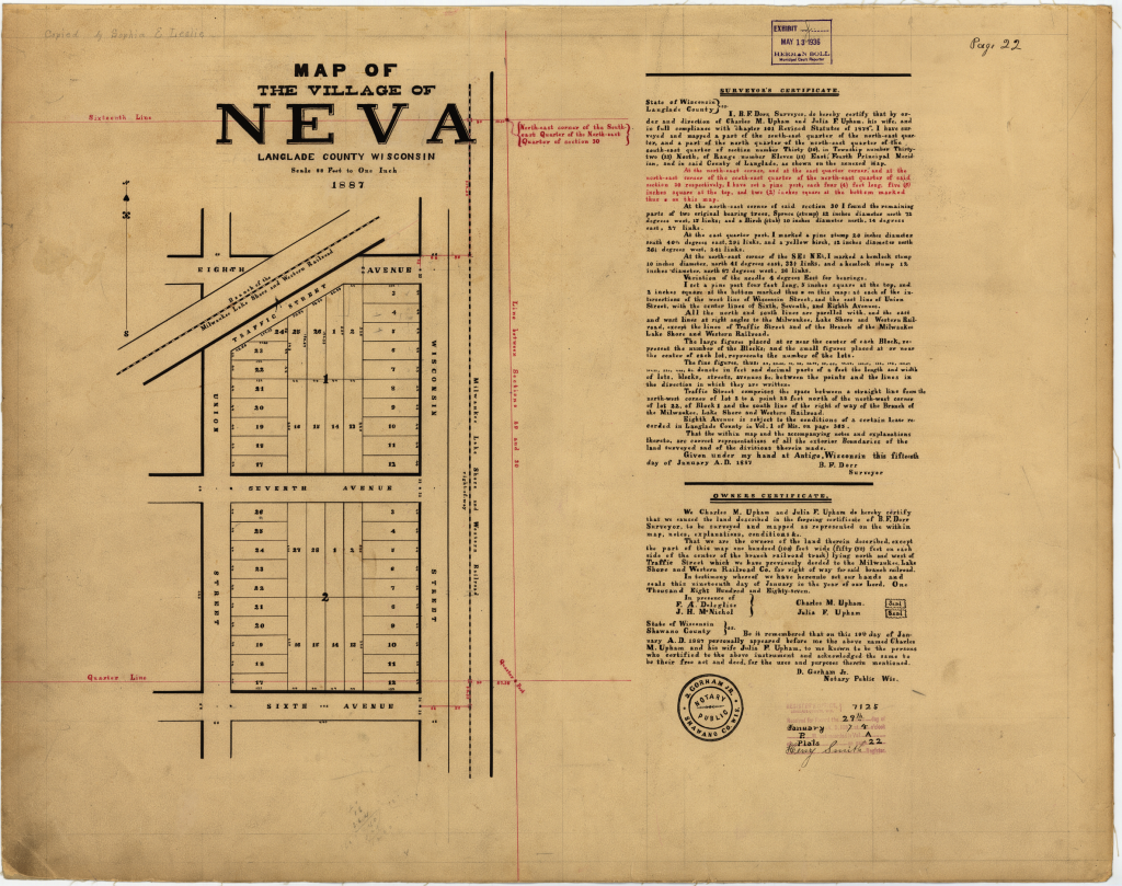
If you have Martha Lucas’s work the above map is exactly what you will see. So far it does not look as if the rail spur was ever built. It would be typical to plat a planned rail spur when filing with the county. The railroad line also lends to some making the wrong conclusion this is Deerbrook.
The railroad at Deerbrook did get a rail spur that lead to Neva (Neva Corners) but not anything in the location we see here.
The red lines in both plat maps represent the section markers on how this area is divided. The north east marked description is in the exact location to fit the theory I am about to show. This plat does not include the Eau Claire River. Deerbrook was a lumber town, not a farming district. Neva Corners became the farming area as things progressed.
All of this and much more information, if included here, would make this post much more complex and long. So the choice was made to omit some and use summaries.
As for Warren Woodruff and Edward Dawson. This is the first physical proof I have of an Edward Dawson in this area. I’ve checked with several county historical societies; each bringing me the same result, “you already know more than we do.”
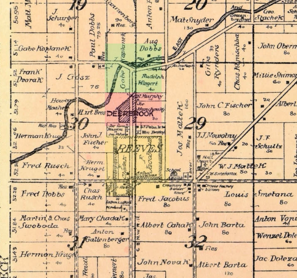
The above map is the current theory of what is happening in this area. Deerbrook is in green, the Village of Neva is in red and the Village of Reeve in yellow. Section markers on both original plat maps strongly support this theory. The area between the Village of Reeve and the Village of Neva was never platted. From the looks of this 1913 plat map I can assume they were already owned by individuals. My Great Grandfather, William Bentley being one of the owners.
My theory is Deerbrook’s original location is where the green is. Deerbrook was a fast growing community. Location allowed Deerbrook to grow at a quicker pace than the other areas. Timber was the primary industry, the Eau Claire River was big enough to float logs to market and there were mills to process to finished lumber. Neva became the farming center of the area.
Upham was in the business of selling land. Woodruff was a major lumber producer in Oconto County. Reeve appears to lumber, although more research is needed these careers fit with what could be expected to happen.
As Deerbrook clear cut the area it began to shrink. Having once grown to include (annex) both the Village of Reeve and the Village of Neva; it came to shrink from both the north and the south; leaving Deerbrook in the middle and leading to confusion or lack of research in these other histories.
There is one final point I want to put to rest about Deerbrook. It was not formerly known as anything. It was in fact the first of these three communities having rail service for passenger and freight speaks how large and how quickly the area was growing. They would not have provided passenger rail service to a community of 10 people. Below find the 1882 Wisconsin map of the railroad lines. Notice Deerbrook and Kempster are clearly labeled and marked with stations.
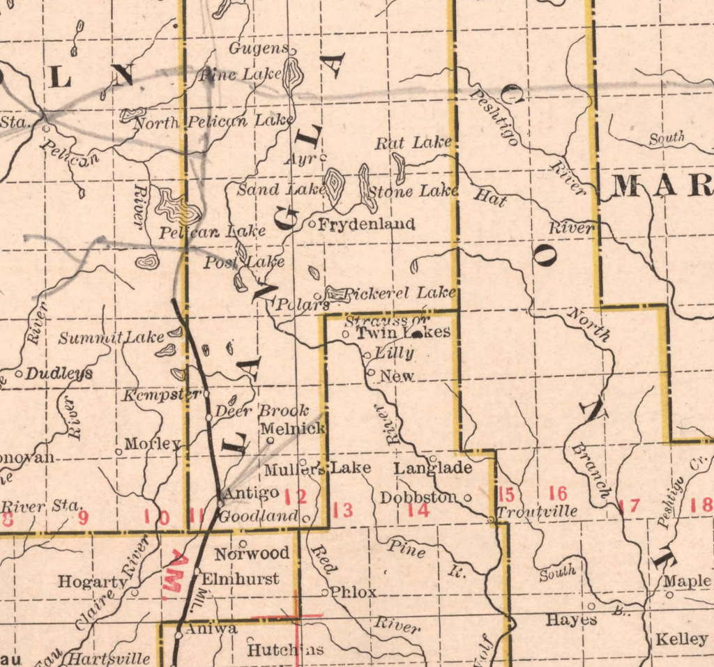
A final conclusion that leads to a possible question. Notice Deerbrook is located north of the Eau Claire River on this map. We have two possibilities, first the map maker put the location in the wrong place; or is it possible this was the original location of Deerbrook? Only local search will answer these kinds of questions. More maps of the time, plats of land sales and how this truly unfolds is where this answer will be found. Clearly historical information we have leaves more questions than they answer.
Deerbrook is truly a wonder. A community everyone knows today, the one community that survived history yet, today it is one no one can answer who formed Deerbrook and where was it truly located when it was created.