
We often fail to realize when searching for information on our ancestors the importance of dates and county names. The impact of what we are searching for is much greater than most realize.
This post discusses why county names are important. For this I will be using La Pointe County, Wisconsin, created on 19 February 1845 by the Wisconsin Territory.
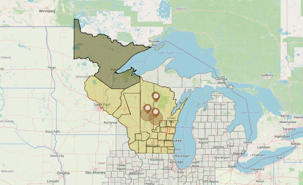
As we often find when counties are formed they are massive land areas eventually split up to additional counties over time. At the time La Pointe is formed it covers a good portion of what will become Minnesota and goes into Canada.
One specific note, when La Pointe County is created it is attached to Crawford County “for judicial purposes”. This means until 1 April 1849 all judicial records will be in Crawford County and not La Pointe.
On 1 April 1849 La Pointe is detached from Crawford County and attached to St. Croix County “for judicial purposes”. Now all judicial records will be in either Crawford or St. Croix counties. On 1 July 1850, La Pointe County is detached from St. Croix and we can assume from this date forward judicial records will now be in La Pointe County because it wasn’t attached to any other county at this time.
For 16 years this goes through several changes before becoming Bayfield County, Wisconsin on 1 May 1866. For 21 years La Pointe County existed, grew with people and businesses. Many businesses incorporated the county name in their business name, such as newspapers.
Today you often know the current county name when beginning your research, spending hours researching records in Bayfield County and Bayfield County didn’t exist until 1 May 1866.
You can see even knowing La Pointe, you often keep thoughts in boundaries you understand today. Even reaching statehood, La Pointe County covers a larger area than most would think.
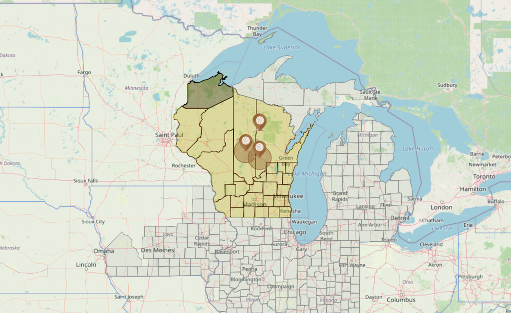
With two maps showing how La Pointe County changed in three years you can see in those three years a much larger search area, or a lot closer information on where the event occurred needs to be known. Remember during these years we depend on church records due to states not having a defined law for recording marriages, births or deaths at either the state or county level. If your ancestor was born between these two dates you may find the church holding records of your ancestors in Minnesota.
Without understanding how counties changed over time, searching is more complex then we are thinking. AniMap helps to sort out these complexities by showing you what counties looked like during the time you are searching.
The maps also point if a business used La Pointe in their name, during these years the business may have been located as far north as Canada. These areas have a detailed and rich history based on trade needs and accessible routes of travel when they were being formed.

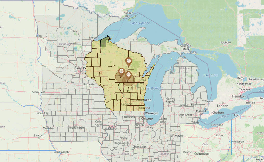
Here we see another situation with county development. Notice the line on the southwest corner of La Pointe County, this represents an overlap between La Pointe and St. Croix Counties when Wisconsin state law created this change. These areas indicate records for ancestors born in these years could be listed as either La Pointe or St. Croix adding further confusion in your search without having the benefit of AniMap to reveal this issue. Overlap of county boundaries is not as uncommon as one might think they are or should be. When legislation was created a lot depended on how current the survey was when working to create the law; they didn’t have computers to keep surveys up to date as they are changed.
Notice the area in red, this is a non-county area created by Wisconsin state law. Like newly formed counties that were not fully organized, it is assigned to an organized county for judicial and government purposes. Non-County areas are legal areas, with names and places ancestors could have been born. In the above map the red area is Non-County Area 10.
During all these years businesses came and went, churches were constructed and records were recorded. Every change does change the scope area of your search for records; it can change the names of the places you need to search especially in the case of newspaper sources that have come and gone through the years.
Names and boundary changes play a major role in your genealogy research and finding this detailed of information on those changes is tiring and can take a massive amount of time; yet it is needed to document the story of your ancestors.
Two more maps to point out one other occurrence in boundary changes that happens more frequently than we think.
In the map above we see La Pointe County on 5 June 1860. This boundary change is showing area lost to the creation of Ashland County. On this date we are still about six years away when La Pointe will be renamed Bayfield.
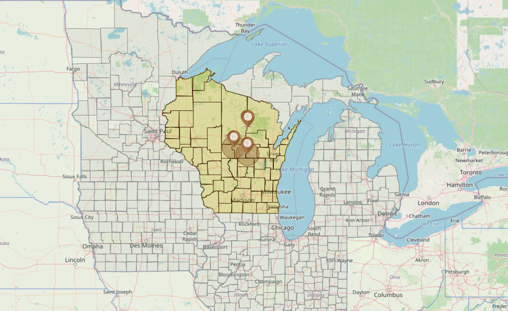
Two things happen on this map, first you can see La Pointe is no longer darker than any other county on the map. This is because on this date La Pointe County ceased to exist as it is renamed Bayfield County, also this is why the caption switched to Bayfield County. One other thing happens here on this date. Just before La Pointe is renamed it regains some area from Ashland County that was lost when Ashland County was created.
This visual can be confusing. Up until 5 June 1860 in the small area lost (second map up); your ancestors were born in La Pointe. For the six years after this date, until 1 May 1866 you could have ancestors born in Ashland County and your ancestors never moved from the land they owned or the communities they lived in. This shows clearly how over time places didn’t move but boundaries did. We can have ancestors living in the same place for hundreds of years that were born in different counties all while never moving from the very spot the settled in.